 |
 |
Kepler Trek, New Zealand 
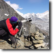
The Kepler trek is a new trail opened in 1988 to handle the over popularity of the Milford and Routeburn treks. While not claiming to be comparable, it does share much of the same old growth spendor of lush, green forests as the two more popular hikes. In addition, it offers great views from the bluffs, Brod Bay, red beech trees and great bird life including redpolls, tomtits, bellbirds, blue ducks, pesky keas, and much more.
While not as grand as Milford or Routeburn, it is a worthy trek, especially if you can't get on the crowded trails. Indeed, I was able to change my itinerary at the last moment to accommodate the bad weather forecast. This wouldn't be possible on either the Milford or Routeburn treks.
.
Fundamentals Days Trekking: 4 days
Highlights
When to Go Similar to the Milford Trek, the main trekking season is from late October to late April. However, some people choose to trek off season when the DOC huts are not necessarily staffed. If you go off season you will also have to contend with an increased risk of avalanches and slips. The Kepler Trek is not as popular as the Milford and Routeburn treks. Still it is advised that you book your trip well in advance. The reservations start in July.
Guided vs Independent Treks There is only independent trekking for the complete circuit of the Kepler Trek. As an independent walker you may take advantage of the DOC huts (open and staffed in high season only), but you must be self-sufficient with your food and equipment needs. The huts provide a bunk to sleep on (you need only your sleeping bag), flush toilets and cooking stoves. They are staffed by wonderfully knowledgeable, helpful and witty staff. It is by far the best, most organized and competent system I have seen in the world. For more information on booking an independent trek visit www.doc.govt.nz. Although you cannot take a guided trek for the entire circuit, there are some options available for day hikes.
|
Map of Kepler will be added shortly
Elevation Map will be added Shortly Add Elevation Map
Access / Local Information The main access city is Te Anau, which is a small town that can meet all of your last minute preparatory needs. You can either drive or take a bus to Te Anau from the much larger city of Queenstown, which is a short flight from Christchurch or Auckland. If you are already in New Zealand you can also take a bus or drive from Christchurch. Queenstown offers a lot more shopping and activities for adrenaline junkies including bungee jumping, zip lining, paragliding and more. Be aware that both towns exist primarily around tourism and it is expensive to buy quality equipment. Therefore, it is best to have all your equipment purchased in advance and use the towns to purchase food for your treks.
Orientation The Kepler Trek, the heart of Fiordland, is located in the south west corner of New Zealand.
|
Day to Day Account - Jeff Salvage - Routeburn Trek, New Zealand
 After completing both the Milford Trek and Routeburn Trek I wanted to see if Kepler Trek was up to par. Far easier than Milford or Routeburn to get a permit for, the Kepler trek was advertised as a comparable experience. Given that I had time, I decided to find out for myself. Historically, Kepler was different in that it wasn’t a traditional trade or hunting route, but was intentionally designed as an international trekking route in 1988 to take the spillover of traffic from the two very popular hikes. The story continues...
