 |
 |
Grand Canyon, Rim to Rim to Rim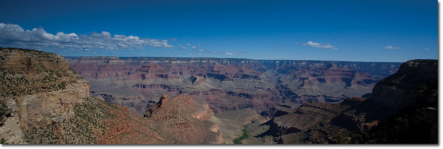
The American Southwest is an amazing geological wonder. Fascinating rock formations, Anasazi ruins, vast deserts and great rivers. The greatest is the magnificent Colorado: winding its way from the high Rockies of its namesake state through Utah and Arizona, ultimately, emptying into the Sea of Cortez. In truth, very little water makes it that far, as much of it is now diverted and dammed to quench the thirst of the great suburban desert metropolises of Los Angeles, Las Vegas and Phoenix. However, this hasn’t stopped the river from making itself known as the great creator of one of the world’s true natural wonders.
In northern Arizona the Colorado River makes its way through, in fact it cuts through, the granite uplift of northern Arizona, forming the ninety-mile long by one-mile wide Grand Canyon. This cut is nothing short of spectacular. Although, there are many other canyons and gorges in the world, and having seen numerous contenders, we can assure you there is nothing comparable to the breadth, depth, character and color of the Grand Canyon. Indeed, there is nothing like it in the world!
Although it took three million years to form this ultimate hiker’s destination, the good news is you can hike the heart of it in as few as three days. In a lifetime one could hardly complete exploration of all the side canyons, nooks and crannies. However, you can get an excellent taste of what the American Southwest and the Grand Canyon have to offer. Hiking the canyon rim-to-rim-to-rim provides you the widest and deepest experience. The benefit, of course, is that you experience the geology of both rims, the inner canyon and the river itself.
There are several variations to this hike. There are multiple trail options on the South Rim, so you don’t completely retrace your footsteps and you don’t have to organize a shuttle as is necessary if you went just rim-to-rim. Our recommendation is to start at the South Rim and descend via the South Kaibab Trail. You can stay at Phantom Ranch Campground or Lodge upon your descent. Then head up toward the North Rim via the North Kaibab Trail staying the night at Cottonwood Campgrounds. In the morning you can leave your camp set up and day hike, without the added weight of your pack, to the North Rim. You can then return to sleep at Cottonwood before heading back up on the Bright Angel Trail the next day.
Fundamentals Days Trekking: 3-6 days
Highlights
When to Go The ideal Canyon seasons are late spring and late fall. Winter brings snow on the rims, especially the North Rim. Summer is unbearably hot. Carrying an overnight backpack is not recommended at this time. This is especially true in the inner canyon where the lower elevation and canyon walls make it an oven and nearly unsuitable for anything but early morning or late day hikes.
Guided vs Independent Treks There are many options hiking independently. Permits are available through the National Park Service starting the first day of the month, one year in advance for any day that month. The prime trails and campgrounds fill up quickly so get your reservation in early.
|
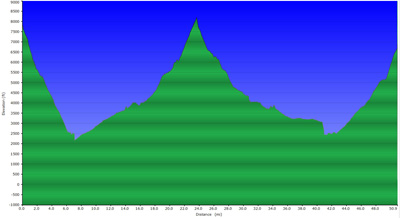
Elevation
Access / Local Information For accessing the South Rim, Phoenix is your best bet. The South Rim Village is a four-hour drive from Phoenix. Flagstaff is much smaller and closer, only a two-hour drive, but has a more limited flight selection. It is an eight-hour drive from LA. The North Rim is easily accessed from Las Vegas, Nevada in a five-hour drive.
|

Day to Day Account - Jeff Salvage - Grand Canyon - Rim to Rim to Rim, U.S.A
 Trekking rim-to-rim-to-rim in the Grand Canyon requires good timing and proper preparation. Mid-September was far from ideal as temperatures at the bottom of the canyon might reach 38° C / 100° F during the day. A dry heat maybe, but with 50 or more pounds on your back, it is far from pleasant. The problem is if you wait until much later in the season it can get quite cold at the rim. The story continues...
